
RST Apology to Tasmanian Aboriginal people 2021.
RST Apology to Tasmanian Aboriginal people 2021.

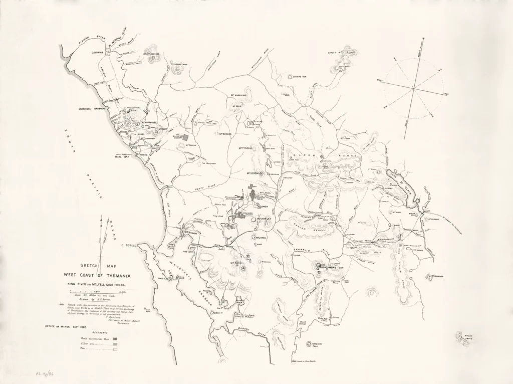


Sketch map of the West Coast of Tasmania 1887
This 1887 map for prospectors includes King River and Mount Lyell Gold Fields and is drawn by G.F. Lovett. It was issued with the sanction of the Hon. Minister of Lands & Works by F. Belstead Secretary of Mines, Hobart, Tasmania and was intended only for the guidance of prospectors, as the features of the country were not from the actual survey, and its accuracy could not be guaranteed. The map shows a track to Strahan, proposed tracks, and old tracks, including J. Franklin's 1842 track. It also shows mines plus gold, silver and tin discoveries.
(Royal Society Map Collection RS Mp 86) Scale 2 ½ Miles to 1 inch
This is evidently based closely on a map compiled in 1876 by James Scott and drawn by artist William Piguenit in his capacity as draughtsman for the Tasmanian Colonial Survey Department. Scott, like many others, was frustrated by the poor quality of maps then available. There had been several expeditions into the western wilderness, but maps had not been updated to reflect the latest information. Scott’s map was a considerable leap forward, combining his own acute observations with those of Hellyer, Gould and Sprent. The map ‘related the complex ranges and rivers of the area to the location of known tracks and became the first working map of the area for prospectors and others’. Scott’s map became the inspiration for a succession of maps over several decades and this style of mapping lasted for nearly a century.
Besides topology, the map shows the latest tracks including T.B. Moore’s track to Frenchman’s Cap from the King River goldfield (cut in February 1887) and Gould’s track (1859/60). Gould had been appointed Government Geologist in 1859 with a brief to find gold as a panacea for the economic difficulties Tasmania experienced as a result of the Victorian goldrush.
Prints are scaled to the selected paper size allowing a 20mm margin for matting and framing. If you would like to order a map printed to the original document size then please contact the RST office for a price and to order.

The Royal Society of Tasmania acknowledges, with deep respect, the traditional owners of this land, and the ongoing custodianship of the Aboriginal people of Tasmania. The Society pays respect to Elders past, present and emerging. We acknowledge that Tasmanian Aboriginal Peoples have survived severe and unjust impacts resulting from invasion and dispossession of their Country. As an institution dedicated to the advancement of knowledge, the Royal Society of Tasmania recognises Aboriginal cultural knowledge and practices and seeks to respect and honour these traditions and the deep understanding they represent.
On 15 February 2021, the Royal Society of Tasmania offered a formal Apology to the Tasmanian Aboriginal people.