
RST Apology to Tasmanian Aboriginal people 2021.
RST Apology to Tasmanian Aboriginal people 2021.


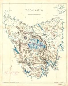


Tasmania - Lands & Survey Department 1883.
This map of Tasmania from the Lands & Survey Department, N.J. Brown, was drawn by Edward Randolph Wolfe Castray and published by J. Souter No. 73 St. Pauls Church Yard London. Castray was first appointed to the Colonial Government service in Jan 1876. By mid 1891 he had moved to Launceston where he was the Deputy Registrar of Births, Deaths and Marriages; the Clerk in Charge of the Lands Titles Office; and Clerk and Draftsman of the Lands and Mines Department. The map includes superimposed manuscript images by George I. Lovett. The heights of mountains are red, lakes are blue, and range systems are grey.
Royal Society Map Collection RS Mp/8
Prints are scaled to the selected paper size allowing a 20mm margin for matting and framing. If you would like to order a map printed to the original document size then please contact the RST office for a price and to order.

The Royal Society of Tasmania acknowledges, with deep respect, the traditional owners of this land, and the ongoing custodianship of the Aboriginal people of Tasmania. The Society pays respect to Elders past, present and emerging. We acknowledge that Tasmanian Aboriginal Peoples have survived severe and unjust impacts resulting from invasion and dispossession of their Country. As an institution dedicated to the advancement of knowledge, the Royal Society of Tasmania recognises Aboriginal cultural knowledge and practices and seeks to respect and honour these traditions and the deep understanding they represent.
On 15 February 2021, the Royal Society of Tasmania offered a formal Apology to the Tasmanian Aboriginal people.