
RST Apology to Tasmanian Aboriginal people 2021.
RST Apology to Tasmanian Aboriginal people 2021.

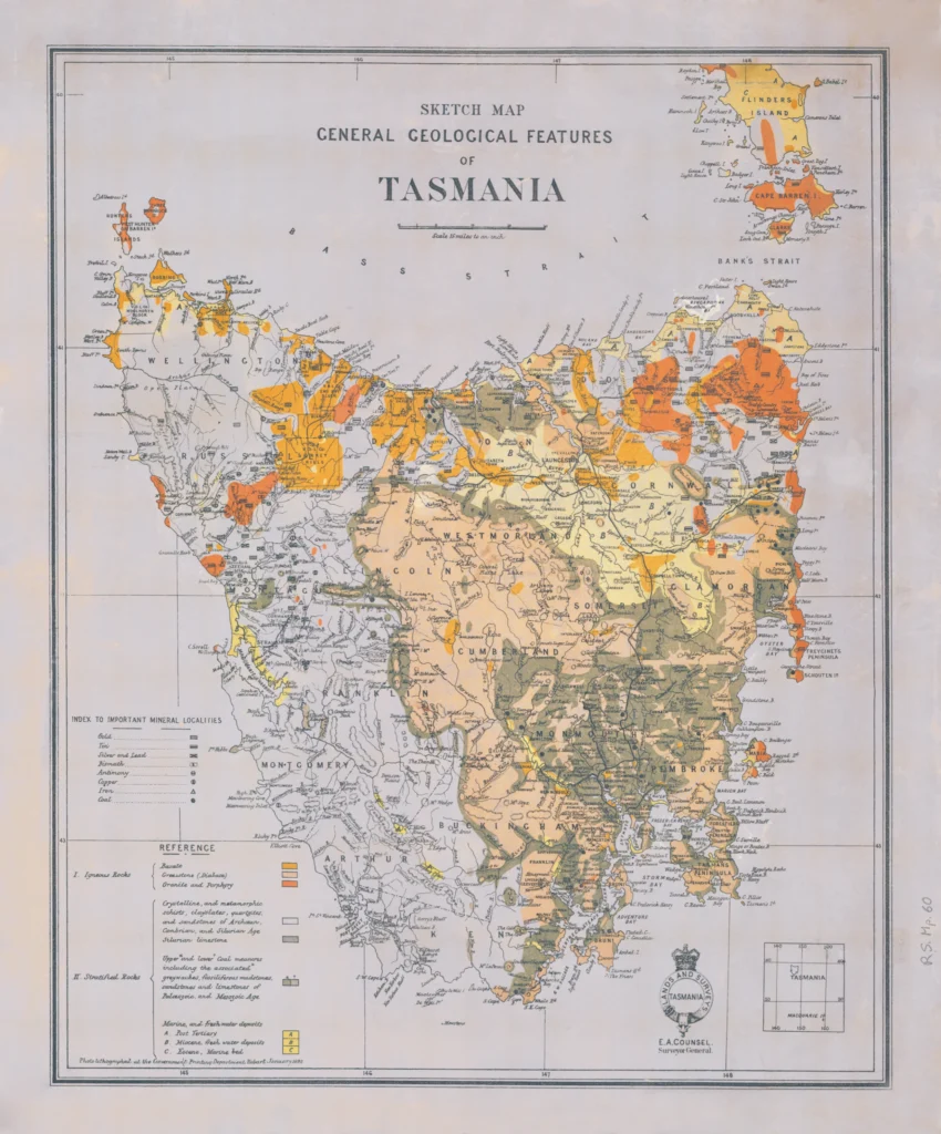


Sketch map of geological features of Tasmania 1892
Sketch map of geological features of Tasmania 1892, created by E.A. Counsel, Surveyor General, Lands and Surveys Department, Tasmania and published in 1892 or 1893. The map shows varieties of rocks, minerals and metals. (Royal Society Map Collection RS Map 60)
This map was issued at the height of the mining boom in Tasmania. With the sudden end of the property boom in Melbourne and the terrible depression that affected the Australian colonies in the 1890s the eastern goldfields of Western Australia and the mines of western and north-east Tasmania were one of the few locations where work could be found. This map, prepared by the Mines Department, was published by the Lands and Surveys Department as a guide to would be prospectors.
Scale: 1 inch: 15 mile
Prints are scaled to the selected paper size allowing a 20mm margin for matting and framing. If you would like to order a map printed to the original document size then please contact the RST office for a price and to order.

The Royal Society of Tasmania acknowledges, with deep respect, the traditional owners of this land, and the ongoing custodianship of the Aboriginal people of Tasmania. The Society pays respect to Elders past, present and emerging. We acknowledge that Tasmanian Aboriginal Peoples have survived severe and unjust impacts resulting from invasion and dispossession of their Country. As an institution dedicated to the advancement of knowledge, the Royal Society of Tasmania recognises Aboriginal cultural knowledge and practices and seeks to respect and honour these traditions and the deep understanding they represent.
On 15 February 2021, the Royal Society of Tasmania offered a formal Apology to the Tasmanian Aboriginal people.