
RST Apology to Tasmanian Aboriginal people 2021.
RST Apology to Tasmanian Aboriginal people 2021.

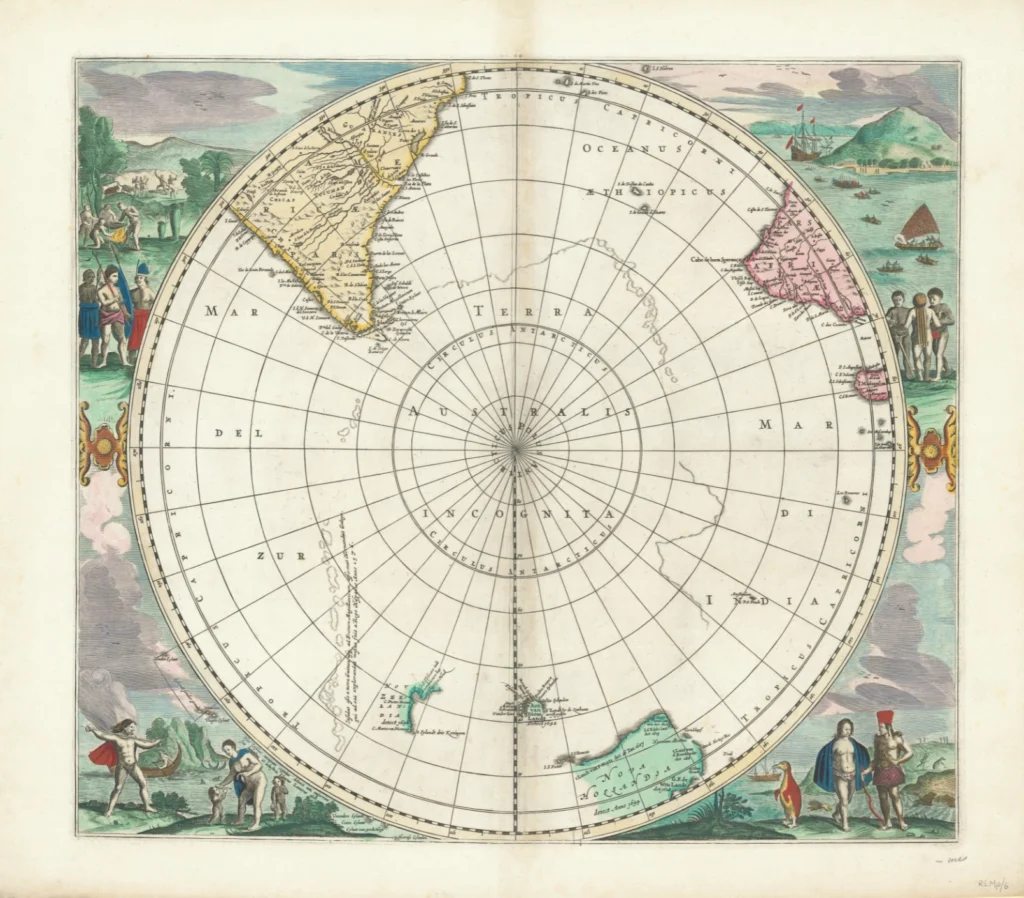


Polus Antarcticus Joannes Jansonius (1657) from The Royal Society of Tasmania’s Map Collection
Polus Antarcticus. Created by Joannes Jansonius (1657). The 1685 re-edition included the results of Tasman's first voyage. It shows Nova Hollandia 'detecta 1644', part of Zeelandia and 'Ant. van Diem. Landt' 'detecta 1642', also St. Francis and St. Peter's Islands. It is bordered by coloured scenes of natives and animals." (Royal Society Map Collection RS Mp 6)
Johannes Janssonius (1588–1664), with his brother in law, owned bookstores in many cities in Europe and reproduced versions of Mercator’s map. By 1660 there were 11 volumes of his maps created by many authors and engravers but this map appears to be a response to results of Abel Tasman's first voyage (1642–1643). The map shows the South Pole in the centre but with no real detail – although there is some rough shading of islands and peninsulas. It also shows South America, Cape Horn and Tierra del Fuego (the latter two had been mapped during the Magellan expedition, 1519–1522), as well as Van Diemen’s Land (mapped by Tasman, 1642) and the southern part of Africa and Madagascar. Coloured images around the outside of the map show penguins, the native people of Tierra del Fuego, and of Africa, as well as hunters of south America. Images also include lions and penguins in the same image (!) lower right. Paper folio from book. Original Size: 47 cm x 42 cm.
Prints are scaled to the selected paper size allowing a 20mm margin for matting and framing. If you would like to order a map printed to the original document size then please contact the RST office for a price and to order.

The Royal Society of Tasmania acknowledges, with deep respect, the traditional owners of this land, and the ongoing custodianship of the Aboriginal people of Tasmania. The Society pays respect to Elders past, present and emerging. We acknowledge that Tasmanian Aboriginal Peoples have survived severe and unjust impacts resulting from invasion and dispossession of their Country. As an institution dedicated to the advancement of knowledge, the Royal Society of Tasmania recognises Aboriginal cultural knowledge and practices and seeks to respect and honour these traditions and the deep understanding they represent.
On 15 February 2021, the Royal Society of Tasmania offered a formal Apology to the Tasmanian Aboriginal people.