
RST Apology to Tasmanian Aboriginal people 2021.
RST Apology to Tasmanian Aboriginal people 2021.

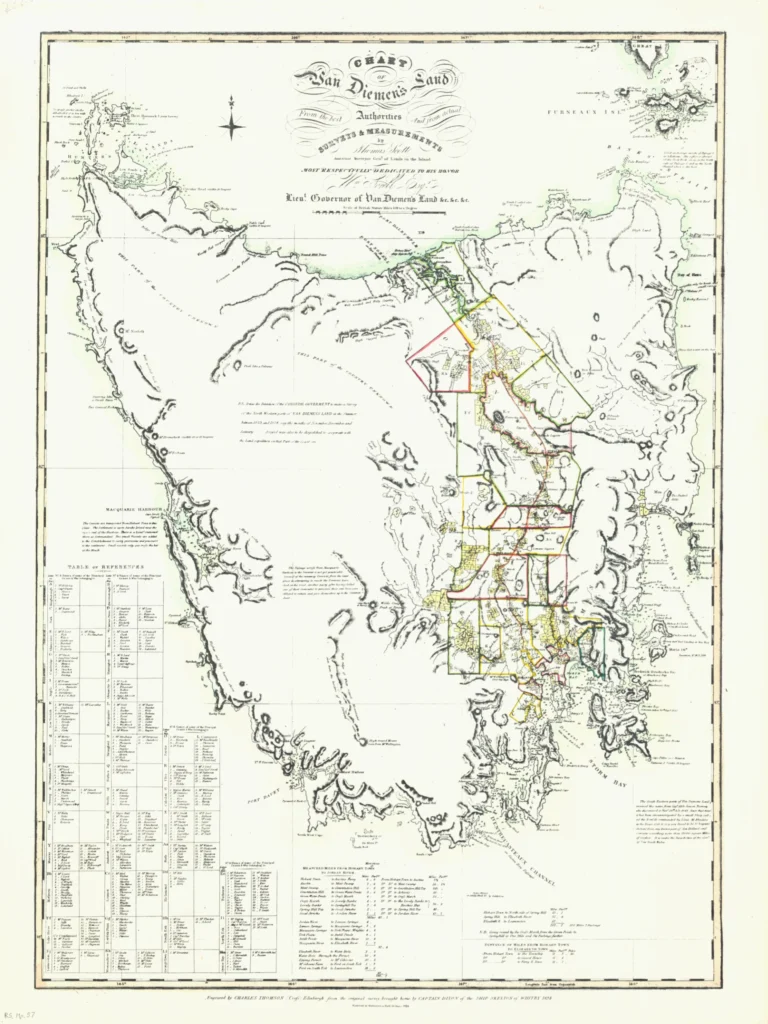


Chart of Van Diemen's Land 1824
A Chart of Van Diemen's Land from the best authorities and from actual survey by Thomas Scott, Assistant Surveyor General of Lands in the Island. Most respectfully dedicated to William Sorell Lieutenant Governor.' The map was engraved by Charles Thomson (Cross) Edinburgh from the original survey brought home by Captain Dixon of the ship Skelton of Whitby. Published in 1824, the map shows names of grants and mileages.
Thomas Scott (1800–1855) arrived in Van Diemen’s Land in 1820 and was appointed assistant surveyor under deputy surveyor Evans. It was the beginning of the arrival of many free settlers with varying amounts of capital to start a new life in Van Diemen’s Land with free Grants and convict labour. The comparison between Evans’ chart and that of Scott two years later is remarkable. Evans and party had made a detailed exploration of Macquarie Harbor and due to his surveying exploits, the East Coast was better known. Grants were being taken up at Oyster Bay. The other parts of the island were still unknown.
Original size: 67.5 cm x 90 cm.
Royal Society Map Collection RS Mp8
Prints are scaled to the selected paper size allowing a 20mm margin for matting and framing. If you would like to order a map printed to the original document size then please contact the RST office for a price and to order.

The Royal Society of Tasmania acknowledges, with deep respect, the traditional owners of this land, and the ongoing custodianship of the Aboriginal people of Tasmania. The Society pays respect to Elders past, present and emerging. We acknowledge that Tasmanian Aboriginal Peoples have survived severe and unjust impacts resulting from invasion and dispossession of their Country. As an institution dedicated to the advancement of knowledge, the Royal Society of Tasmania recognises Aboriginal cultural knowledge and practices and seeks to respect and honour these traditions and the deep understanding they represent.
On 15 February 2021, the Royal Society of Tasmania offered a formal Apology to the Tasmanian Aboriginal people.