
RST Apology to Tasmanian Aboriginal people 2021.
RST Apology to Tasmanian Aboriginal people 2021.

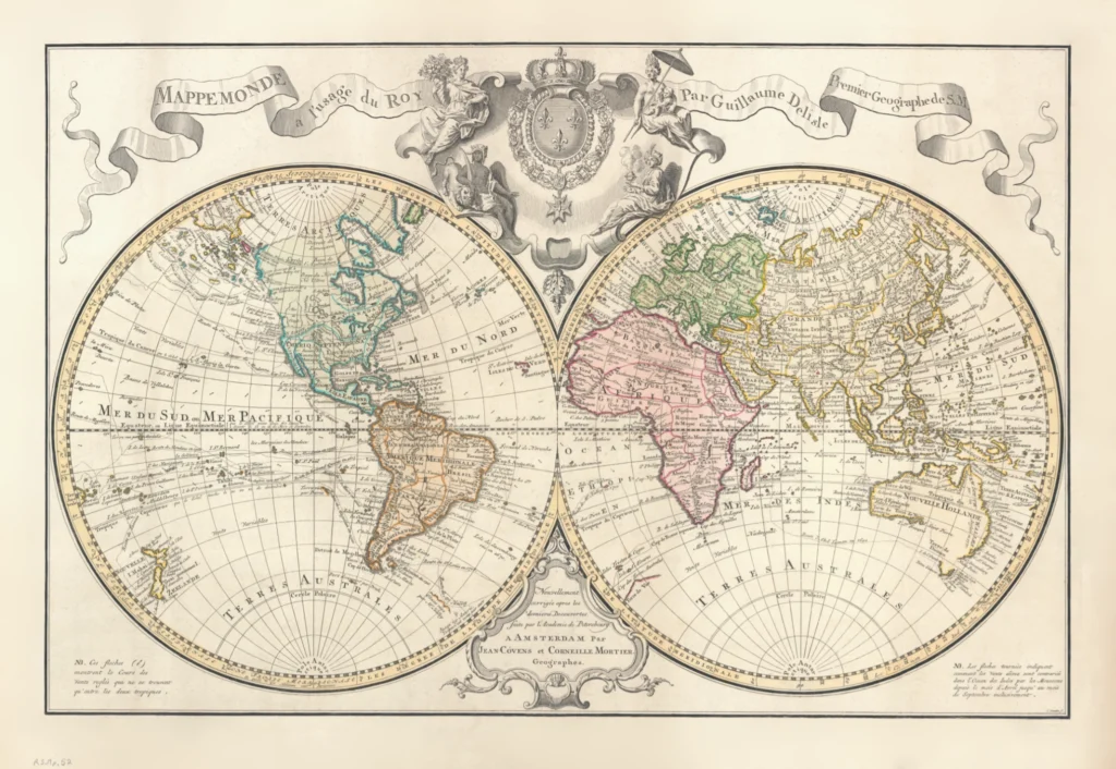


The World in Two Hemispheres, de Lisle, Guillaume 1770-1800
Mappemonde a l’Usage du Roy
This map by Guillaume de Lisle was created in the late eighteenth century (c. 1770–1800). It depicts the world in two hemispheres. By this time, Nouvelle Hollande is nearly complete apart for some of its southern parts where confusion remained around the coastline of what is now Bass Strait. The map also depicts Terres Australes around the Antarctic or southern polar circle. The title and its creator are presented in an ornate scroll at top with royal arms and decorative figures.
It's full title notes that this edition includes new knowledge after the ‘new discoveries made by the Petersbourg Academy’ and that it has been updated and corrected by geographers Jean Coven and Corneille Mortier in Amsterdam and printed by Johannes Condet.
(RS Mp 52 paper, 43 cm x 65 cm)
Royal Society Map Collection RS.Mp52
Prints are scaled to the selected paper size allowing a 20mm margin for matting and framing. If you would like to order a map printed to the original document size then please contact the RST office for a price and to order.

The Royal Society of Tasmania acknowledges, with deep respect, the traditional owners of this land, and the ongoing custodianship of the Aboriginal people of Tasmania. The Society pays respect to Elders past, present and emerging. We acknowledge that Tasmanian Aboriginal Peoples have survived severe and unjust impacts resulting from invasion and dispossession of their Country. As an institution dedicated to the advancement of knowledge, the Royal Society of Tasmania recognises Aboriginal cultural knowledge and practices and seeks to respect and honour these traditions and the deep understanding they represent.
On 15 February 2021, the Royal Society of Tasmania offered a formal Apology to the Tasmanian Aboriginal people.