
RST Apology to Tasmanian Aboriginal people 2021.
RST Apology to Tasmanian Aboriginal people 2021.


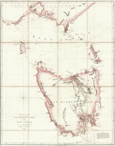


Chart of Van Diemen's Land and Bass’ Strait.
This map was created and published by A. Arrowsmith, no. 10 Soho Square London in 1922. Arrowsmith was hydrographer to His Majesty. The map shows Port Philip Bay (New South Wales). (Royal Society Map Collection RS Clark Bequest Mp 3)
Arrowsmiths were a major printing and engraving firm in London in the nineteenth century and this map, with its tinted surface, is more than a chart for mariners to navigate by. The references to good pasture land and rivers are directed also to attracting immigrants.
Prints are scaled to the selected paper size allowing a 20mm margin for matting and framing. If you would like to order a map printed to the original document size then please contact the RST office for a price and to order.

The Royal Society of Tasmania acknowledges, with deep respect, the traditional owners of this land, and the ongoing custodianship of the Aboriginal people of Tasmania. The Society pays respect to Elders past, present and emerging. We acknowledge that Tasmanian Aboriginal Peoples have survived severe and unjust impacts resulting from invasion and dispossession of their Country. As an institution dedicated to the advancement of knowledge, the Royal Society of Tasmania recognises Aboriginal cultural knowledge and practices and seeks to respect and honour these traditions and the deep understanding they represent.
On 15 February 2021, the Royal Society of Tasmania offered a formal Apology to the Tasmanian Aboriginal people.