
RST Apology to Tasmanian Aboriginal people 2021.
RST Apology to Tasmanian Aboriginal people 2021.


Bass Straits and the Islands, M. Flinders, 1814.
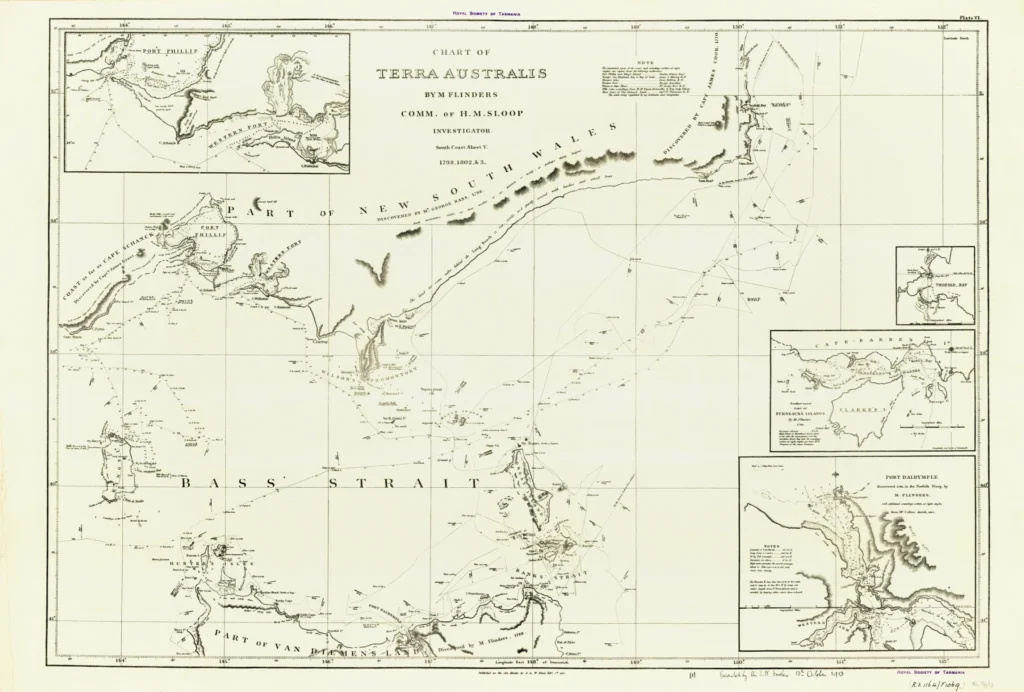
'Chart of Terra Australis by M. Flinders comm. of H.M. Sloop Investigator, south coast sheet V, 1798, 1802 & 3 Including Bass Straits, King Island, Furneaux Islands and other islands, north coast of Van Diemen’s Land including Port Dalrymple, Tamar River and part of the south east coast of Australia including Port Philip. Inset plans are of Port Dalrymple, Port Philip etc. The map was published as the Act directs by G. & W. Nicol on Feb. 1st 1814'. (RS Mp 13)
Prints are scaled to the selected paper size allowing a 20mm margin for matting and framing. If you would like to order a map printed to the original document size then please contact the RST office for a price and to order.

The Royal Society of Tasmania acknowledges, with deep respect, the traditional owners of this land, and the ongoing custodianship of the Aboriginal people of Tasmania. The Society pays respect to Elders past, present and emerging. We acknowledge that Tasmanian Aboriginal Peoples have survived severe and unjust impacts resulting from invasion and dispossession of their Country. As an institution dedicated to the advancement of knowledge, the Royal Society of Tasmania recognises Aboriginal cultural knowledge and practices and seeks to respect and honour these traditions and the deep understanding they represent.
On 15 February 2021, the Royal Society of Tasmania offered a formal Apology to the Tasmanian Aboriginal people.